In Part 2 of this Photogrammetry Test I take a look at the point clouds and discover that the overlaps have a far more pronounced affect on the outputs.
Before getting into Part 2 I have been asked a few questions on the eBee and on the processing.
Firstly with the eBee X I use the SODA 3D camera. When setting up the survey in eMotion I set the camera to take oblique shots on both sides at 30 degrees (this is in addition to the NADIR images).
With regard to the processing for the orthomosaics I set the resolution to 1 x GSD. For the point clouds I set the image scale to 1/2 image size with the point density "optimal".
As reported in Part 1 I found that there was a disparity between the reported point cloud count density compared with my analysis undertaken in ArcPro and Global Mapper. One matter I have noted is that PiX4D refer to the point cloud count on a cubic metre basis whereas my analysis was on a m2 basis. I can see that this may lead to some issues with tall vertical surfaces but less so when reviewing fields or general terrain which is free of any tall structures or indeed vegetation.
I have set out below 5 images of the point cloud for each of the overlaps and and added the following data;
The legend on each plan shows the number of points per m2 over a range of point densities.
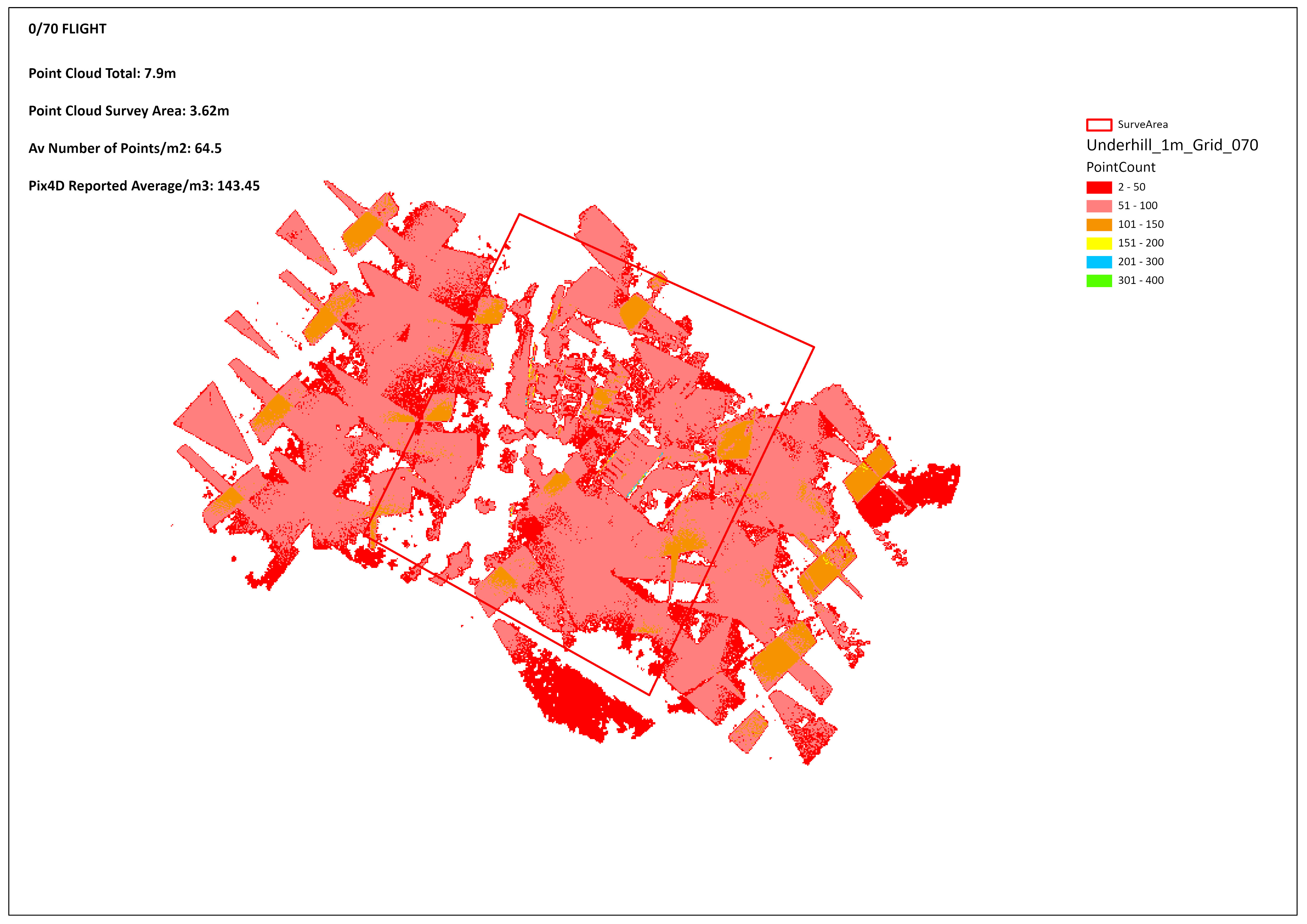
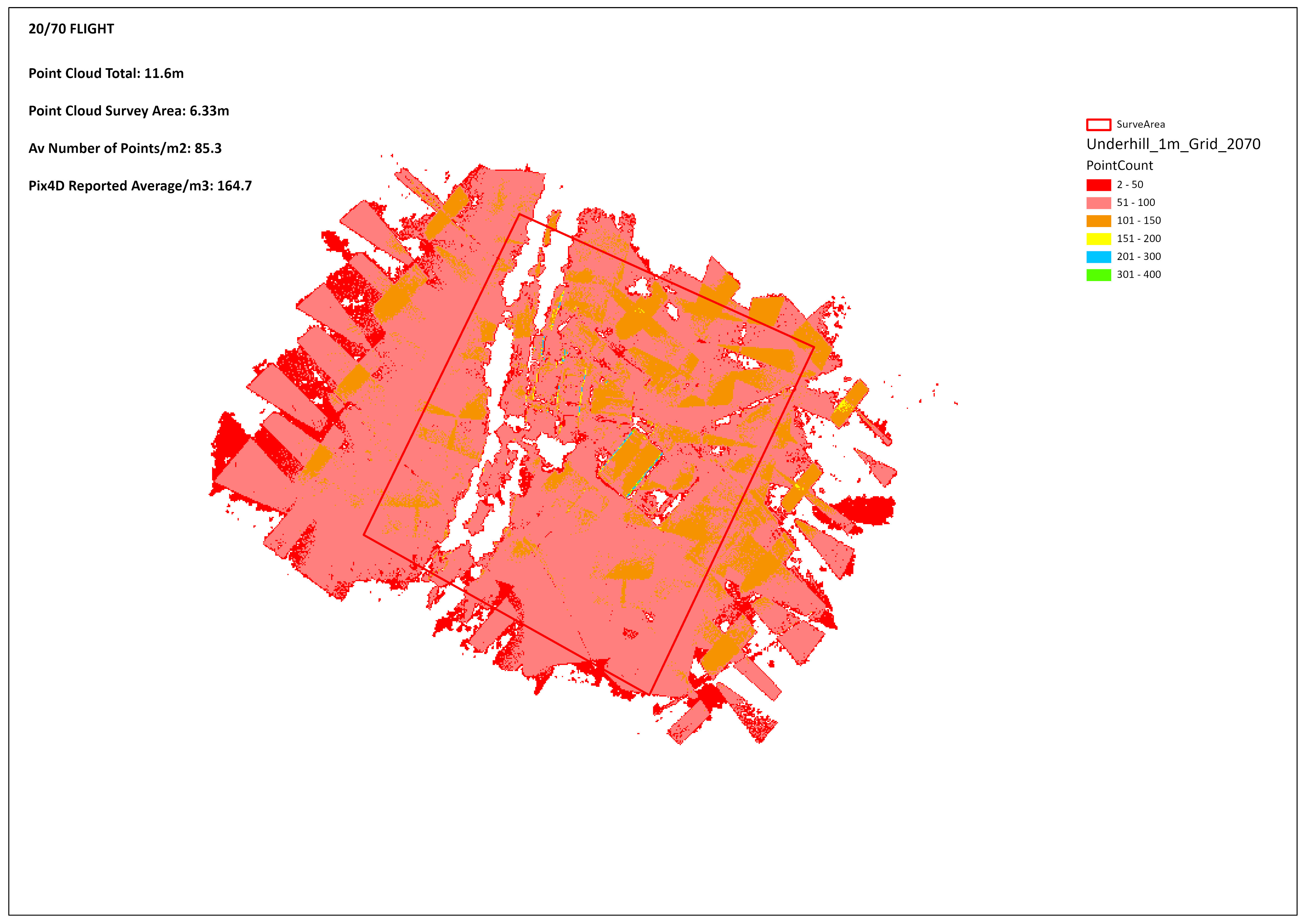
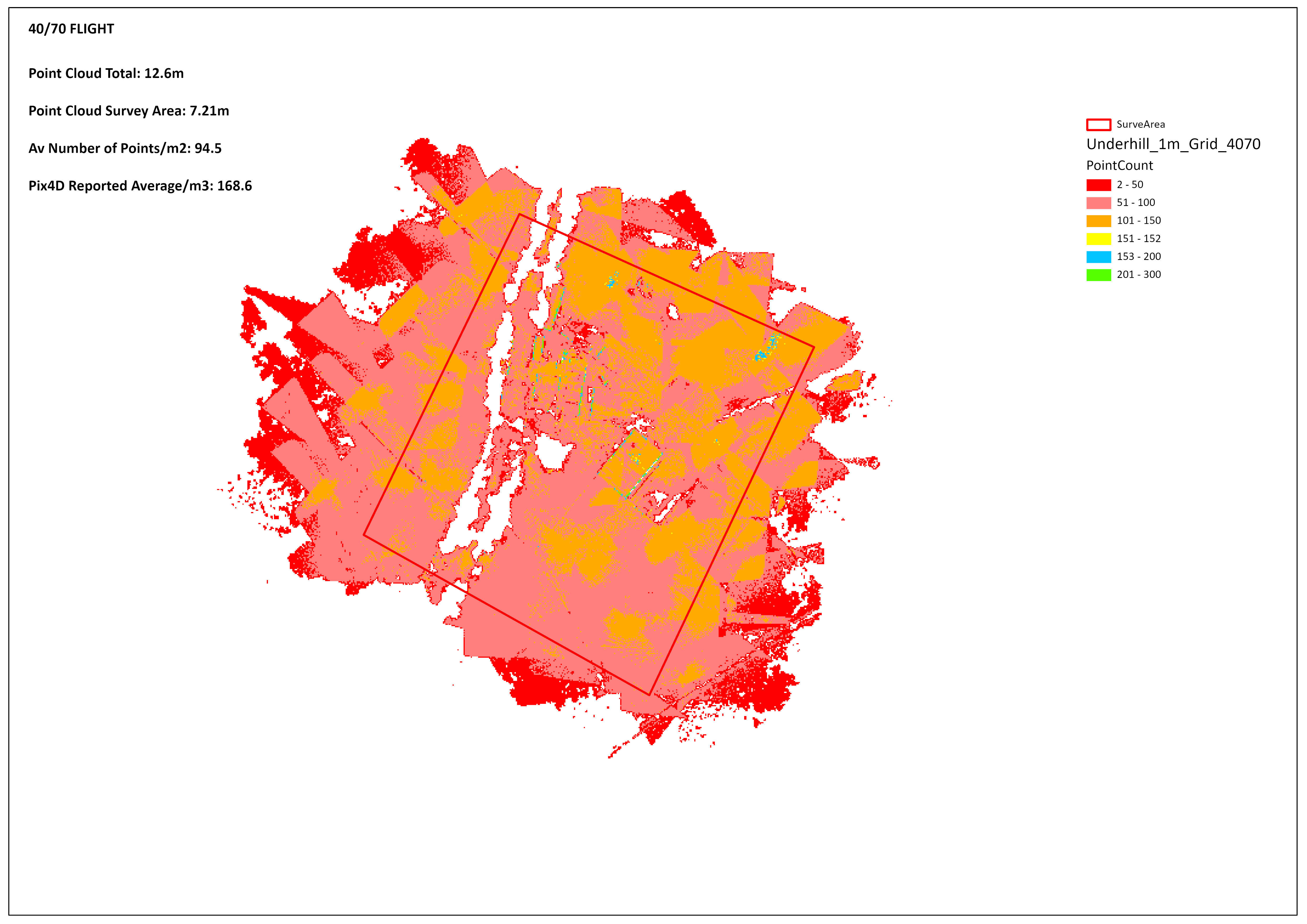
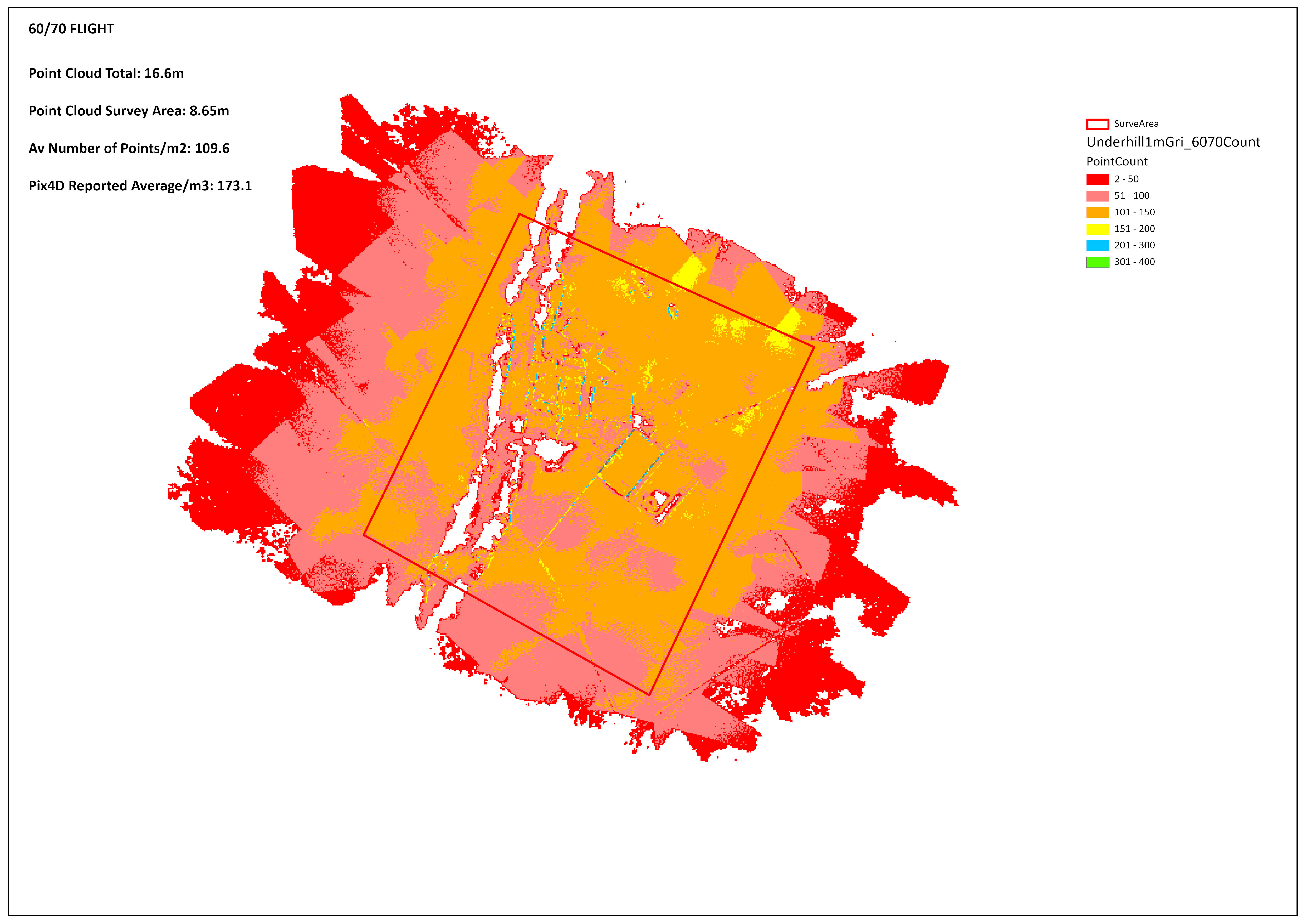
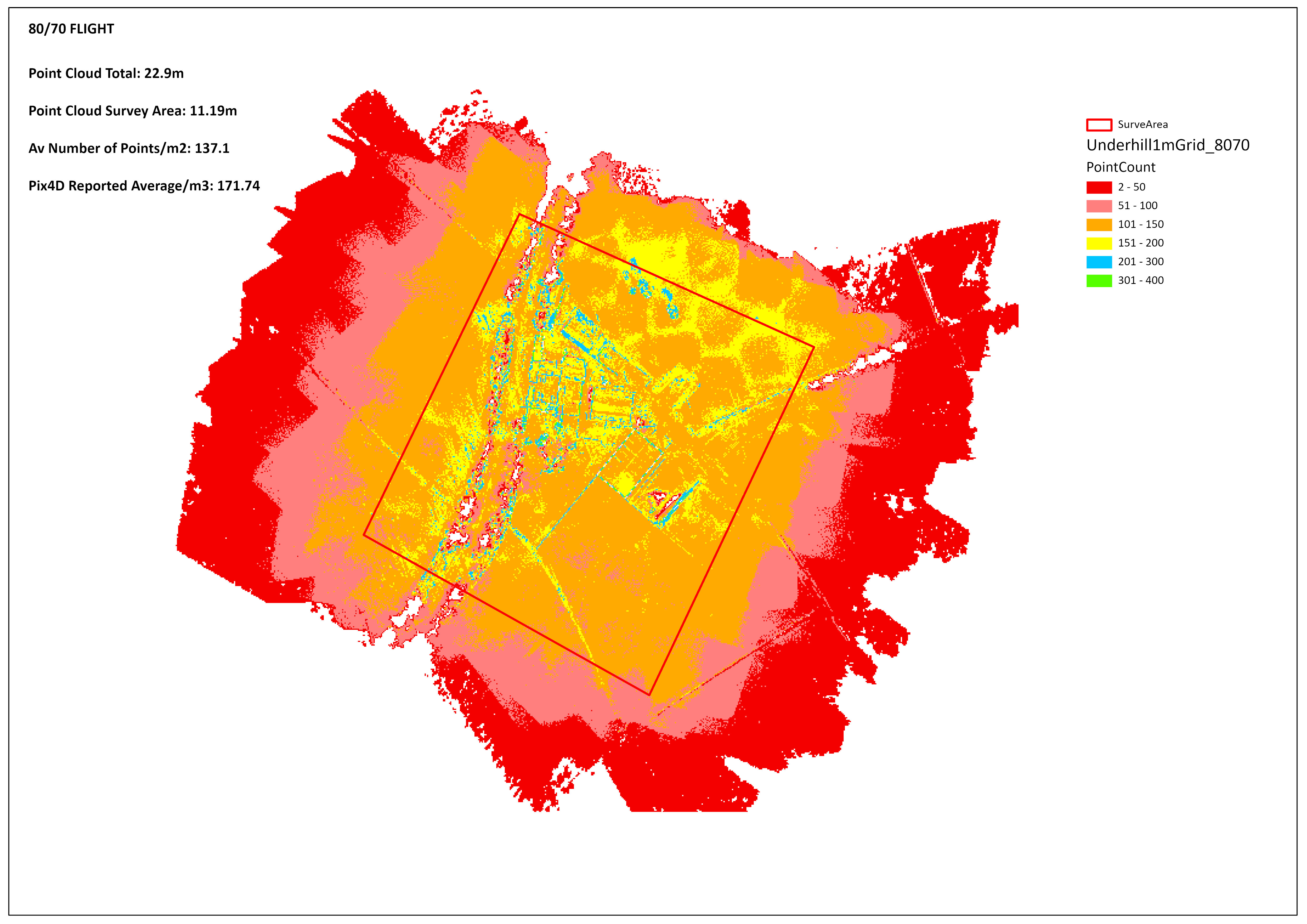
As can be seen there is a marked difference between the 0/70 and 80/70 surveys. In particular where there are buildings or tall vegetation gaps appear in the point cloud. Whilst the SODA 3D camera does an excellent job with the undulating fields when using the 0/70, 20/70 or 40/70 the reduced number of passes dramatically reduces the number of NADIR images. This is bourne out by the outputs. In addition the extent of tree canopies (in particular) become distorted and much larger.
An important factor which I hope to understand further is point cloud density. I will be taking this up with Pix4D so that I can understand why there are variances between reported and actual figures. On final observation would be that 80/70 or 80/80 would give much better results where there are buildings or structures as would increasing the point cloud image scale and point density during processing.
The final part was viewing the point cloud models (as opposed to a mesh) in 3D. I use Global Mapper for managing and editing point clouds and produced a fly through for each of the surveys. The video can be viewed here https://youtu.be/pstDdL1f9OQ.
For the next stage I produced Ditigal Surface Models from the point clouds. I didn't edit the point clouds. I haven't shown the DSM's here but all 5 showed the same elevations.
To conclude this has been an interesting test and with some surprising results. The eBee with the SODA 3D camera managed to create some good orthomosaics even at the 0/70 and 20/70 settings. With the huge savings in flight times and/or conversley the ability to cover much larger areas on a single flight. The opposite side of the equation, the generation of point clouds, clearly needs overlaps at the higher end. Going forward I will carefully consider the settings I use and in doing so be very mindful of the end uses for the data. The worst outcome would be to fly a site at a lower overlap only to have to fly it again to capture some better quality data.
I have had involvement with surveying for much of my career and have been using drones for the last 6 years. Photogrammetry is sometimes referred to as a "Black Art" but clearly there is a scientific underpinning. With an understanding of the processes involved with a sound workflow right from planning and collecting the the data through to delivery of the outputs you can get consistent and reliable results. I think there is a huge upside for clients as they can have to hand timely and accurate data to manage their businesses with many other added benefits not least cost and H&S matters. For some clients in the construction sector my services are now integral to their operations and I work closely with their engineering teams, land surveyors and opertional teams. Drones do make a positive contribution to the the construction sector and improve productivity.