This blog starts in the early 1980's when I worked for Tarmac Roadstone East Midlands Ltd. I was responsible for the property and planning matters for quarries and associated operations from Cliffe Hill in the south to Blaxton, nr Doncaster in the north. Cliffe Hill, or Stud Farm, as I first knew it was the only hard rock quarry, everything else was sand and gravel. At that time Tarmac had invested and acquired interests in sand and gravel reserves in the Trent Valley with a number of operational sites. Also as is common with sand and gravel you were constantly securing planning on extensions to existing operations but time comes when you need to develop a new greenfield site.
Tarmac had acquired an interest in Langford Lowfields which was a substantial resource well located to the market area but with two challenges to overcome. How to access it and how to restore it.
The first challenge was due to there being no easy road access and to get to the site we needed to cross the Newark/Lincoln railway line. We had determined the best point to access the highway, the harder part was sorting out access over the railway line. Clearly a level crossing wasn't going to be an option for obvious health and safety reason so a bridge was proposed. My boss at the time, John Sharpe, dealt with this and as you would expect took a few months to reach agreement.
The second and it turned out the harder issue to solve was the restoration of the site. At that time national planning policy was to restore sites to agriculture at a lower level. Food production and security was key so higher grades of agricultural land were protected. I recall Langford was mainly Grade 3A so we had to demonstrate it could be restored at a lower level. At the time I think only a few sites had be restored at a lower level and we did visit one operation in Lincolnshire to understand the issues. At some sites, the one in Lincolnshire being a case in point, the mineral resource is not part of an active river valley. As such you are primarily dealing with ground water which is manageable. In short you dig a perimeter ditch from which you can pump the water ensuring the low level land doesn't flood. However where you have a resource adjacent to a large river you have both ground water and flood water to contend with.
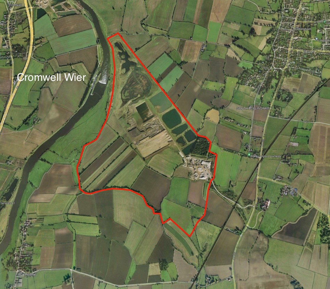
Initially we though we had a solution due to the proximity of Cromford Wier. If you look at the image below the wier can be seen with the site edged red. The River Trent is tidal upto the wier and the tinking was that there would be sufficient water level difference to "drain" the restored quarry following a flood. However two issues arose being (1) the time that land would be flooded as it could take weeks to properly drain and (2) a permanent pumping scheme would be required to maintain levels. It soon became apparent that there were high risks of loosing crops on a regular basis and that the ongoing pumping costs would be significant. The commuted sum for a perpetual scheme at that time was still north of £200k.
A Plan B was required.
I was working with Roger Simon who at the time headed up the geology department trying to come up with a restoration solution when the penny dropped. Instead of restoring to agriculture and trying to keep the water out why not use the water to create alternative uses. We also knew that we had silts and fine sand to ultilize (a by product of the process) together with other materials on site which could be used to create a series of lakes. We sketched out draft plans and the next stage was to get a conservation body on board to verify and support our ideas. This is where the RSPB came in and we presented our proposals to them. The response was very encouraging as this project gave them the opportunity to be part of the design team and tailor the reserve to their requirements. I won't go through the planning process but it did conclude in planning permission being granted for a project which at the time was contrary to policy.
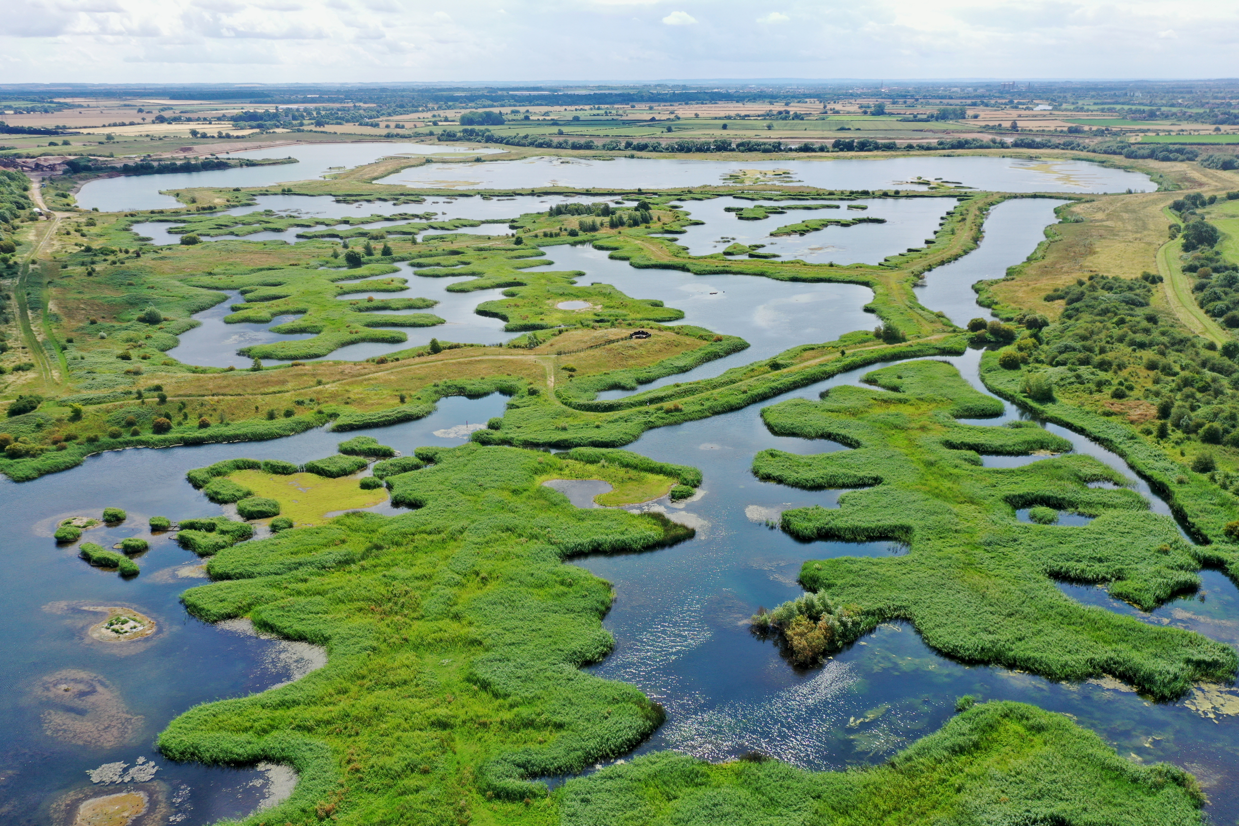
During the early stages of the quarry development I had moved jobs so I no longer had any involvement. Move forward to 2022 and I was able to visit the now restored nature reserve for which I have to thank David McCabe. Langford Lowfields turned out to be so much more that I expected. The reserve that has been created has been done with a lot of attention to detail to create a habitat suited to various species. An indication of this is shown on the adjoining image. You can clearly see the form of the land to create numerous peninsulars and in the distance larger water bodies. Much of the habitat is based on reeds and the managment regime is geared up to increasing the amount of reeds with on ongoing planting programme.
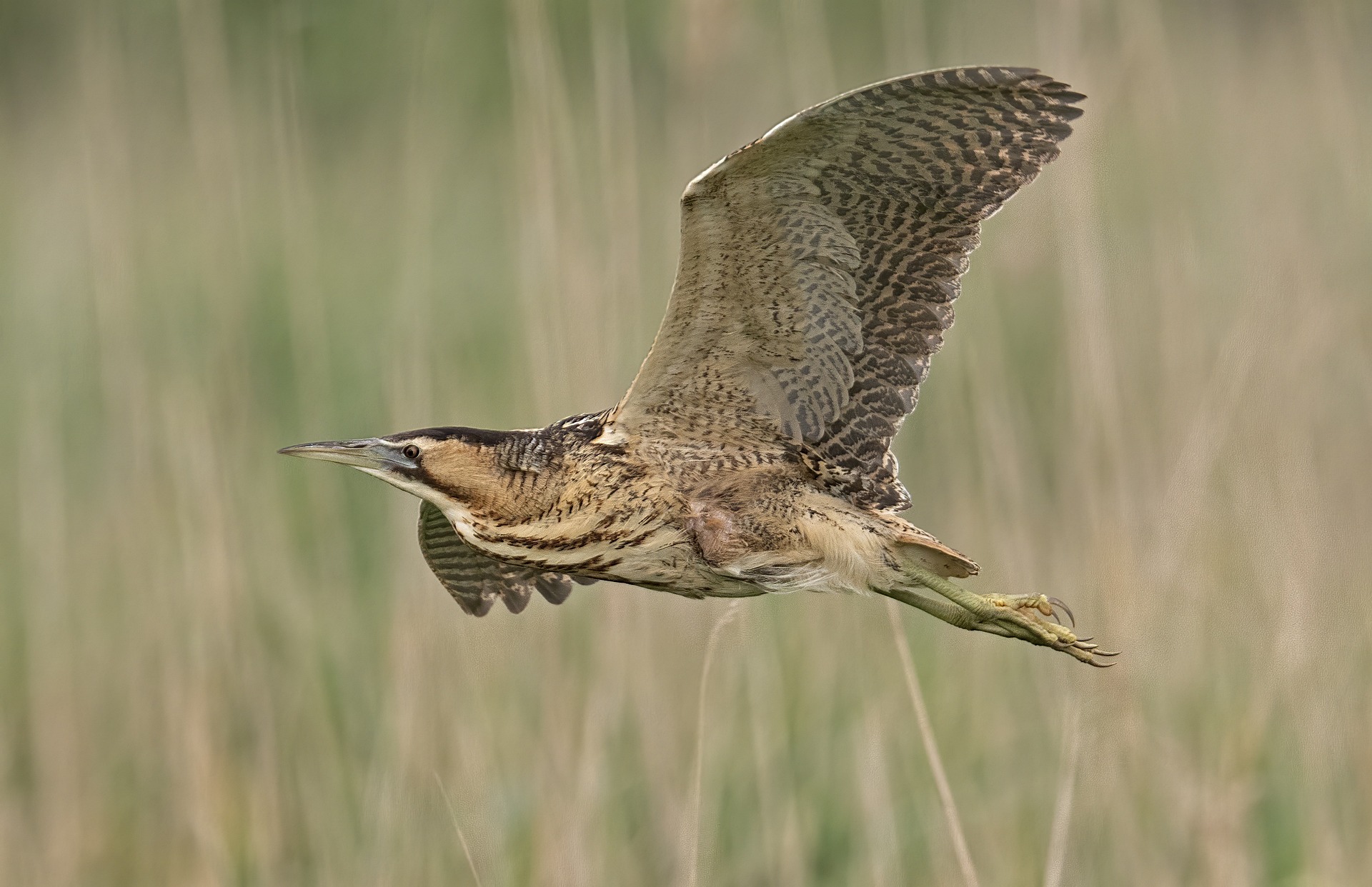
Langford Lowfields has been designed to attract certain bird species with one of those being the Bittern, shown here. The bittern likes to nest in reeds and Langford has the scope and scale to allow a number to nest on site. They are however a bit shy so they are hard to find!! I was very lucky when on site to see one in flight and watched it glide just above the reeds for a few hundred metres. What did surprise me was the size of the bittern, much larger than expected with a wingspan of upto 1.2m.
In Part 2 I talk about the drone survey.
Credit - HenkVanDorp